The UK Quantum Technology Hub Sensors and Timing, led by the University of Birmingham, have partnered with the British Geological Survey, a world-leading geoscience centre for survey and monitoring, to further develop quantum gravity sensors in its second phase.
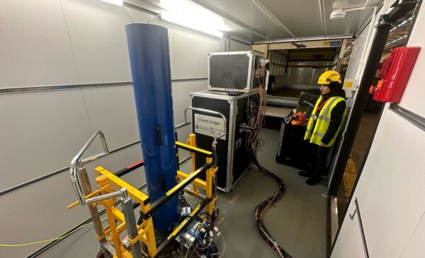
Gravity sensors developed by academics at the Quantum Technology Hub have progressed rapidly during the Hub’s first phase from lab research to prototype instruments. The new partnership with BGS will enable sensors to be tested in real-world environments.
Dr Paul Wilkinson, a Theoretical Research Geophysicist at BGS, said: “We were very pleased to be invited to participate directly in the second phase of the Hub to help develop quantum gravity sensors for use in geophysical surveys and applications.” Dr Wilkinson is working within the Hub’s Geophysics work package, led by Dr Michael Holynski and Professor Nicole Metje, from the University of Birmingham, to set up field trials to test and evaluate quantum gravity instruments and engage with end users.
The development of quantum gravity sensors through to commercial use has the potential to be hugely impactful. It will mean that we will have a much more accurate understanding of what lies beneath the ground. For example, in 2014-15, road occupation due to utility street works incurred costs of more than £1.5 billion, and traffic delays accounted for 6.16 million days of work in the UK. The cost of these street works to the UK economy was estimated around £7 billion, and the projected cumulative total cost of utility street works in the UK from 2013 and 2030 is £319 billion.
Costs are increased when holes are dug in wrong places, due to difficulty in ascertaining the position of underground assets. Quantum gravity sensors target fast, accurate measurements and images, helping to reduce operational costs in transport and civil engineering.
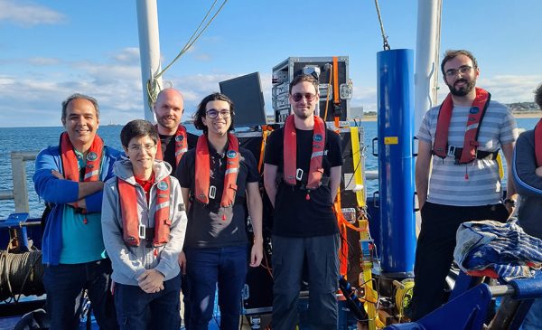
The BGS participation in the Quantum Technology Hub’s consortium, alongside the Universities of Glasgow, Imperial, Nottingham, Southampton, Strathclyde, Sussex and NPL, is an incredibly useful asset to the development of quantum gravity sensors. The BGS operates and maintains state-of-the-art laboratories and national facilities, and has access to a wide range of test sites, allowing the prototype sensor technologies to be evaluated in field trials, to assess their technical and practical capabilities.
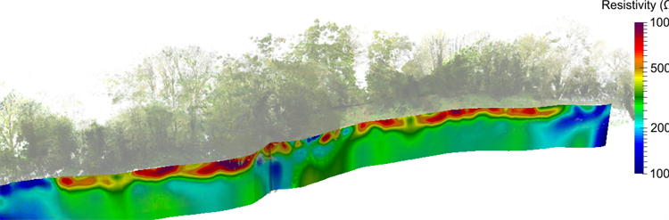
PRIME imaging results showing the distribution of electrical resistivity. The cool colours (light/dark blue) are indicative of leaks from the canal.
Field trials enable testing of sensor instruments, but also ensure that the data captured from the measurements are fit-for-purpose. The BGS have research expertise in a variety of geophysical data, imaging and monitoring methodologies, and of developing novel sensors and systems in collaboration with end users and stakeholders. An example is the PRIME (Proactive Infrastructure Monitoring and Evaluation) system. This is a low cost geoelectrical monitoring platform developed by geophysicists at the BGS, which is now in commercial use and further development with industry. It is specifically designed for remote deployment and operation to monitor geotechnical assets. PRIME is an example of geophysical technology that will be used alongside gravity sensor investigations.
Dr Wilkinson said, “You can set up this technology [PRIME] to make the same set of measurements on a regular basis, and get the data transmitted back as a time lapse sequence. The system takes the data, turns them into 3D images, and translates these into parameters that site operators are more interested in, such as moisture content, and this is delivered automatically to the end-user.”
“We aim to use geoelectrical imaging, and other geophysical techniques as well, to complement gravity investigations. Different techniques are sensitive to different properties of the subsurface, and each has its own strengths and weaknesses. The more methodologies you use, the greater you can reduce the uncertainty.”
Working with the Quantum Technology Hub, will, in Paul’s words, ‘help to deliver the greatest possible impact from the geophysics research being undertaken by the Hub.’
“The prospects of sensitive, stable cold-atom based sensors, alongside quantum-enhanced gravity monitoring networks, offers the potential to significantly enhance our ability to look beneath the Earth’s surface.”
“In particular, there will be exciting opportunities to investigate new joint interpretation and imaging schemes for using multiple sensor types and data streams to monitor subsurface processes.”
Regarding the overall end-user impact, Paul says this will be about “seeing into the ground without having to dig things up. If you have a site or asset that’s permanently instrumented, you can get earlier knowledge of potential problems and you don’t need to send engineers out for repeat surveys, so this can help to reduce costs and improve health and safety.”
“These are things important to society as a whole. While you may not see them, they have a big part in making people safer and helping the environment – inevitably this will have a positive effect.”